Regional & threat intelligence

The maritime threat picture, region by region.

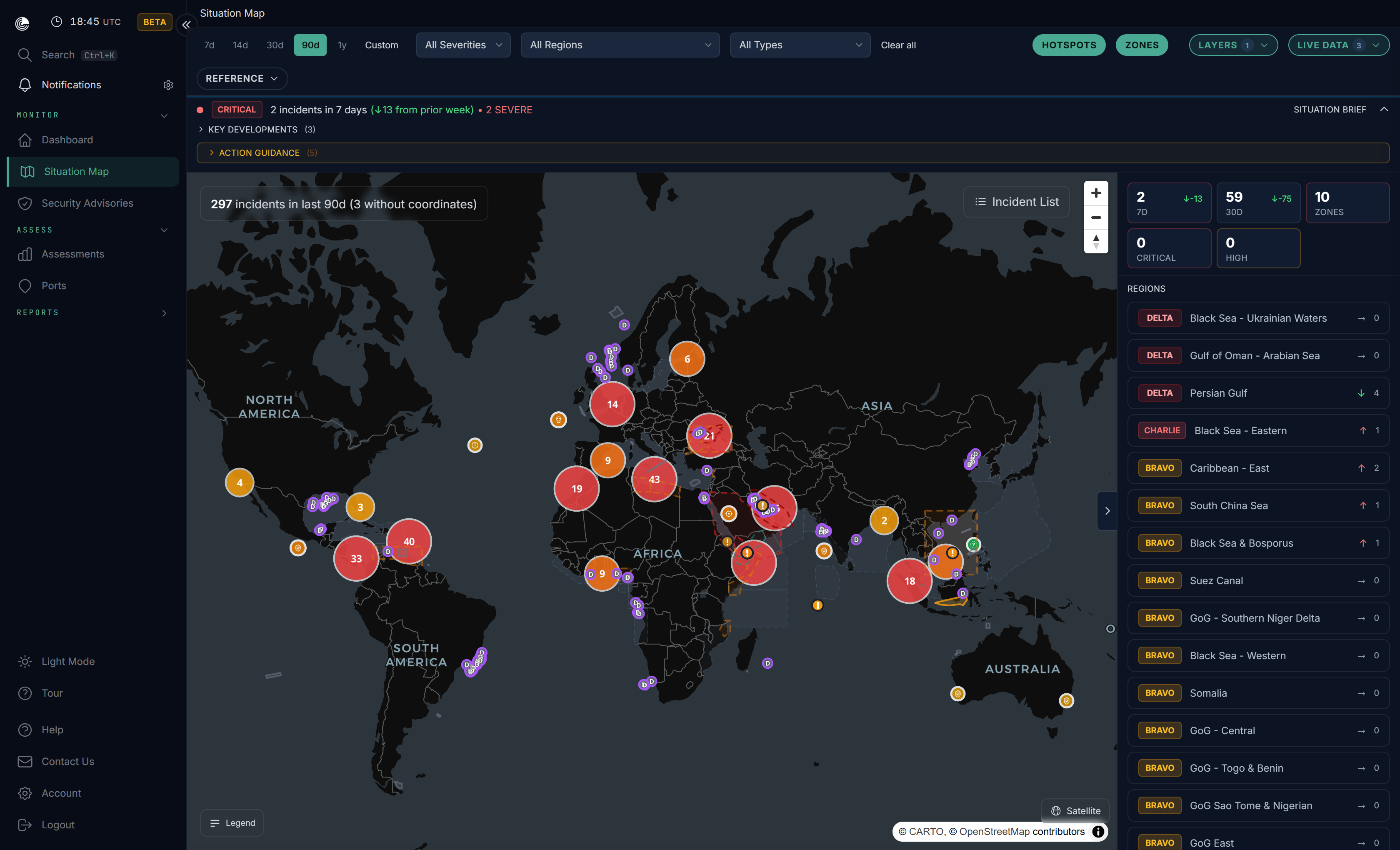
Maritime risk shifts daily and unevenly: a chokepoint heats up, an actor changes tactics, a quiet coast turns active. Verihelm's regional and threat intelligence keeps that picture current and explained, so you can see not just what happened, but who is behind it and what it means for your operation.

Analyst-reviewedPublished assessments reviewed before they reach you Source-tracedIncidents retain source metadata and provenance Situation MapIncidents, threat boundaries and zones in one view
verihelm.dryadglobal.com / situation-map
● LIVE
Verihelm situation map: incidents, threat boundaries and zones across maritime regions
What it is

A continuously maintained view of the maritime security environment.

A continuously maintained view of the maritime security environment: regional and country assessments, classified incident intelligence and threat-actor attribution, brought together on one situation map. Controlled-rollout thematic analysis is available where enabled.

What's in it

Assessments, incidents, actors and a map, in one place.

  • Regional and country risk assessments with threat-condition (THREATCON) levels and narratives that are drafted with artificial intelligence (AI) and analyst-reviewed. Published assessments are analyst-reviewed before publication.
  • Classified incident intelligence, with each incident retaining source metadata and analyst-review provenance. Incidents and advisories are drawn from the standing maritime reporting centres: United Kingdom Maritime Trade Operations (UKMTO) for the Indian Ocean, the Regional Cooperation Agreement on Combating Piracy and Armed Robbery against Ships in Asia (ReCAAP), Maritime Domain Awareness for Trade in the Gulf of Guinea (MDAT-GoG), and the regional maritime security centre for the wider Middle East, together with the International Maritime Organization incident register and selected national and regional authorities. Authoritative-source incident reports can auto-publish under the incident visibility gate; non-authoritative incidents require analyst approval.
  • Threat-actor attribution that links incidents to named actor profiles, profiled by their typical methods, with confidence recorded where attribution is assessed.
  • Situation Map: incident overlays, threat-environment boundaries, Joint War Committee (JWC) maritime zones and port risk indicators in one view.
  • Incident history with a lookback window that scales by tier (90 days, 365 days, or unlimited).
  • Delivered in-platform and as shareable Portable Document Format (PDF) assessments, in regional and country formats.

In controlled rollout: Intelligence Themes group the trends and drivers shaping maritime security, where the feature is enabled.

Why it reads differently

Context, not just an event record.

Incident feeds often stop at the event record. Verihelm adds source provenance, named-actor context, and regional narratives that are AI-drafted then analyst-reviewed before publication, not a static annual note. It is the same intelligence base our analysts work from, surfaced for you.

Who it's for

Built for the people who carry regional risk.

  • Operators, charterers and traders who need the current picture for a region or route.
  • Compliance and due-diligence teams building a defensible record.
  • Insurers and underwriters tracking how a region's risk is moving.
The home of Channel 16

Where we explain the context.

This is the anchor for Channel 16, our maritime intelligence content: region guides, piracy and maritime crime, threat-actor profiles, and in-depth analysis pieces. The assessments above are the shipped product; Channel 16 is where we explain the context behind them.

Get started

See the threat picture for your regions.

Analyst-reviewed regional and country assessments, classified incident intelligence, and threat-actor attribution, on one situation map.